One morning in spring 2025, hunters from the Cree community near Waswanipi walked up a familiar logging road and realized their landmark was gone. Not a cabin or a dock. The water of Lac Rouge itself had disappeared, leaving behind a wide mudflat and stranded fish.
Satellite images later confirmed what the human eye was already seeing. Between late April and mid May, the lake burst through its eastern shore, carved a new channel through the forest, and sent its contents roughly ten kilometers northeast into a larger neighbor, Lac Doda. Amazingly, no one was hurt, even though a nearby road washed out when the water rushed past.
For the Cree families who used the lake for fishing, drinking water, and access to their hunting grounds, it was not just a curious science story. It was like driving out to your favorite cabin and finding only cracked earth where the shoreline used to be.
A rare kind of outburst flood
Scientists classify the event as a sudden lake drainage, sometimes called an outburst flood. Usually, that term is reserved for glacial lakes or reservoirs where an ice dam or engineered wall fails. Here, something far stranger happened.
Lac Rouge was a natural, non-glacial lake with no concrete dam. According to experts interviewed about the event, they could not recall another documented case of a similar lake that fully emptied by tearing open its own shore and abandoning its normal outlet.
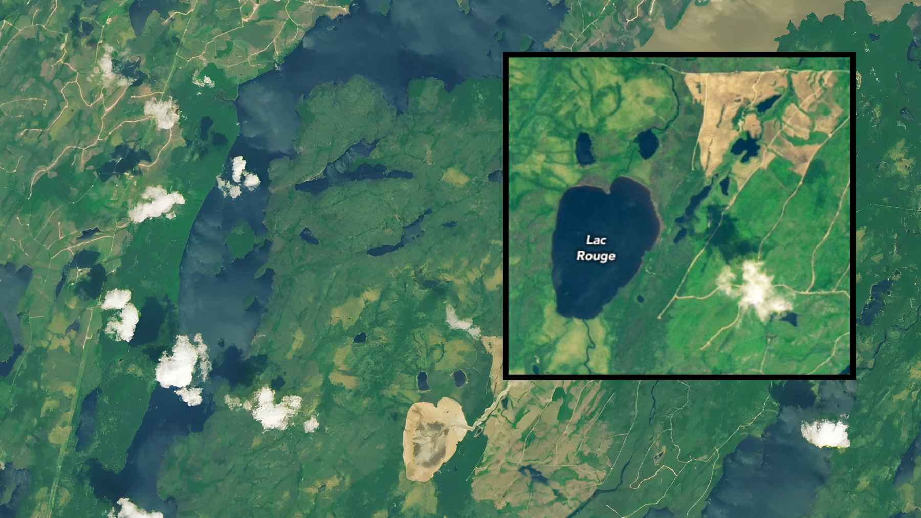
Instead of following its modest existing outflow, the water punched a fresh path through smaller ponds and wetlands before reaching Lac Doda, leaving a pale sediment plume that shows up clearly in satellite imagery. From orbit, the drained basin and new channel look almost like someone dragged a finger through wet paint.
“It is an absolutely amazing case to see,” said Diana Vieira, a scientist who studies these sudden drainage events.
Satellites as detectives in the boreal forest
On the ground, residents first noticed a buckled logging road and a missing boat landing. From space, the timing and scale came into focus.
Images from the OLI 2 instrument on Landsat 9 show Lac Rouge full in June 2024 and bone dry by mid June 2025, with a new tan channel cutting through the green forest toward Lac Doda. Other analyses using Landsat 9 data narrowed the collapse to a roughly two week window in late spring.
Before it vanished, the lake covered an area comparable to a couple hundred football fields, big enough to dominate local maps but small enough to be overlooked on a globe.
That scale is precisely where satellites excel. They can keep an eye on thousands of remote lakes that no one is watching every day from a boat.
In a northern landscape that still carries the imprint of recent glaciers, geologists say that kind of remote sensing is becoming essential. Lakes, rivers, even entire hillsides are still adjusting to the weight of water and ice that disappeared only about fifteen thousand years ago.
Fires, logging and a landscape pushed to the limit
So why did this particular lake fail now? The uncomfortable answer is that no single cause has been proven, but several stressors likely piled up.
The Cree First Nation of Waswanipi, the local Indigenous government, noted in a May 2025 emergency notice that the drainage “may be related to post fire land conditions, snowmelt, or recent rainfall.” In other words, nature had already stacked the deck.
Wildfires burned near Lac Rouge in 2019 and again in 2023, scorching much of the mature forest around its inflows. When trees and their roots are lost, soils lose strength and tend to erode more quickly.
Burned ground can also become water repellent, which sends more meltwater skimming over the surface instead of soaking in.
On top of that, this corner of Quebec has seen decades of industrial logging. Local Cree tallymen and forestry experts told reporters that repeated cutting, road building, and soil scarification have weakened banks and kept the water table higher for longer.
Hydrologist Younes Alila put it simply in one interview. Any disturbance on the land keeps the ground saturated for more days, which slowly saps the strength of lake and river banks.
Add an unusually heavy winter snowpack and a rapid spring melt, and Lac Rouge’s soft, elevated shore had little margin left. At some point in late April or early May, the bank finally gave way.
A warning for other “quiet” lakes
For people living far from northern forests, this might sound like an odd one off. A freak accident in a remote corner of Canada. Yet scientists and Indigenous leaders see it as more of a warning sign than a curiosity.
Regional officials and the Cree First Nation have already urged residents and workers to use “extreme caution” near lakes whose surrounding forests have recently burned or been heavily logged. If one lake can empty with no real notice, others with similar geology and land use histories might be closer to failure than anyone realizes.
For the most part, the lesson here is less about a single vanished lake and more about how many pressures we are quietly placing on landscapes that already sit on unstable ground. Wildfires, clearcuts, quick thaws, undersized culverts, beaver dams that back up water near roads, each piece adds a little more stress.
At the end of the day, satellites can tell us when a lake has gone, but communities on the ground are left to deal with the washed out roads, altered fish habitat, and the loss of a place that held decades of memories.
The Earth observation report was published by the NASA Earth Observatory.